
Thames-Coromandel District Council is urging residents to be prepared for ex-tropical Cyclone Gabrielle, which they say is likely to be similar to the damaging 2018 storm and just below the intensity of Cyclone Bola in 1988.
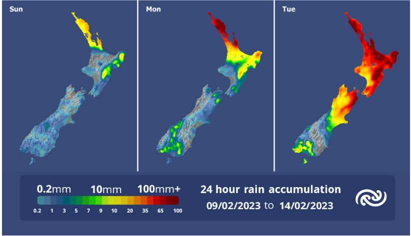
Council has warned ex-tropical Cyclone Gabrielle will bring winds exceeding 135 km per hour and up to 300mm of rain from Sunday.
The storm will also bring storm surges to the east and west coasts resulting in coastal inundation to low lying areas as well as flooding, fallen trees, power outages and road blockages which could potentially cause isolation.

For this reason, the State of Emergency has been extended for another week across the Coromandel, council said.
“A comprehensive update will be provided on Friday, including where we believe inundation and urban flooding could occur.
“On its current course, Gabrielle will be felt on Sunday afternoon with increasing winds and rain, and this will gradually intensify through Monday before the full force hits on Tuesday morning.”
Civil Defence Controller Garry Towler said residents should use the next three days to prepare and plan.
“This cyclone, the fifth severe storm we have had since November last year, is packing a nasty punch, so for those living or staying in lower lying coastal areas think about and plan for evacuation,” he said.
“For everyone on the Coromandel get ready with supplies to last three days, and above everything else lock in a plan to be somewhere safe and secure by next Monday evening.
“An update on the cyclone and what support and resources are going to be available.”
Council encouraged residents to visit the council website and Facebook page for information of local roading conditions and to visit Waka Kotahi/NZTA website for state highway conditions.
If residents spot anything on council roads contact: 07 868 0200 or email customer.services@tcdc.co.nz.
Meanwhile, Metservice meteorologists have issued watches for heavy rain and strong wind for parts of the upper North Island, including the Coromandel Peninsula.
The watches begin in the early hours of Sunday morning, but the most significant rainfall is expected on Monday into Tuesday, where 24-hour rainfall totals could be 200-300m for the Coromandel and 150-200mm for Northland and northern Auckland.
East to southeast winds could approach severe gale in exposed places throughout Northland, Auckland and Coromandel peninsula.
Metservice said it was likely these watches for heavy rain and strong winds would be upgraded to an Orange, or possibly Red, warning in the coming days. It is also likely that additional areas will be added. Stay up to date with all the latest severe weather information at bit.ly/AllWarnings
For now, take advantage of the present settled weather to prepare. More details on that at www.getready.govt.nz